CONTENT
1. Setting the Scene
1.2 Standardisation
1.3 Implementation of metadata services
2.2 Difficulty in selecting and implementing a standard
2.3 Existing services do not communicate
2.4 Capturing and maintaining metadata is not always seen as a priority by data producers
2.5 Minimum collaboration with users during the definition and implementation phases: a user-friendly focus is needed
2.6 Potential users are facing initiatives which are not well documented and advertised
2.7 Doing business with metadata seems impossible
2.8 Metadata for applications
2.9 Several metadata descriptions of the same data set
2.10 Lack of a GI product identification mechanism
3.2 Manoeuvre to generate a period of stability with the focus on implementation, seek consensus on 'how to implement'
3.3 Gather user feedback and identify user needs
3.4 Organise a co-ordination process and clustering approach across projects and initiatives
3.5 Provide incentives for metadata creation and maintenance
3.6 Envisage legislation for public sector metadata content
3.7 Study and implement a GI product numbering mechanism
Annex 1: Survey of on-going initiatives
Annex 2: Acronyms
Abstract
Although a lot of effort has been spent in developing metadata services at European, national, regional, local and sectorial levels, the perception is that users of geographic information still complain that data is not visible enough. One can also say that a large part of this user community does not know of either the meaning or existence of metadata.
Metadata are, as it is usually said, 'data about data'. The aim in developing metadata services is to help users in finding producers and vice versa. Many projects have been launched to make this dream come true: at the European level, for example, with the GDDD, GEIXS, ESMI, EWSE and others. This paper aims to clarify the situation in setting the scene and highlighting the difficulties in creating metadata services (co-ordination, standardisation, metadata capture, etc). Are metadata so useful? Do other solutions to this strategic problem exist? Would it not be better to let the market create a metadata infrastructure instead of trying to make it institutionally? These are key questions for which we would like to find answers.
1. Setting the Scene
1.1 Metadata Studies
1.1.1 GI-META
In 1997, the European Commission/DGXIII launched the GI-META study (report at http://www.echo.lu/gi/fr/docarchive/gi-meta.html) in order to understand better the requirements for metadata services of the European geographic information sector.
The study highlighted that there exist different kinds of metadata products: catalogues, indexes and paper directories, CD-ROMs and a growing range of on-line metadata services. However, there is still a lack of awareness as to what constitutes a metadata service and how it can be used. The report presents the broad user requirements for a metadata service:
- user friendly and multilingual interface that can allow a comparison of data sets,
- updated and constantly maintained service,
- accurate description of data without technical language,
- possibility to order data on-line.
It also stresses the different types of metadata services. Indeed, they can be divided into two: the "broad and shallow databases" (simple data descriptions) and the "narrow and deep databases" (detailed data descriptions of fewer data sets). For the cost/benefit issues, the study highlighted that commercial organisations are aware of the necessity of metadata but see limited benefits in paying to have their data sets included. Advertising was identified as a good way to generate revenue from a metadata service.
1.1.2 VIL
In 1999, the Space Applications Institute of the Joint Research Centre published the report VIL: A Virtual Interoperability Laboratory for Europe. (report at http://ams.emap.sai.jrc.it/). Concerning metadata the report proposes:
" A European Clearing House for all aspects of data (data, metadata, access, marketing, etc.) needs to be established in order to provide a source of information and a centre of excellence for all participants in the GI/GIS community. This Clearing House should address a number of specific concerns, including but not limited to:
- Establishing a multilingual thesaurus, which will allow practitioners in different countries to identify common elements between diverse data sets.
- Be solution oriented by providing sample problems and solutions to which a user can map their own situation.
- Providing an intelligent user agent to translate user needs into data requests through sample situations, questionnaires and any other appropriate tool or facility.
A medium term financial goal is for the Clearing House to become commercially sustainable by selling services, data and consulting activities. A business plan must be defined which outlines the timeframe, milestones and activities to be performed in order to achieve this goal."
1.2 Standardisation
Three main metadata standards exist:
- A US standard adopted in 1994
In the USA the Federal Geographic Data Committee (FGDC) approved their Content Standard for Digital Geospatial Metadata in 1994. This is a national spatial metadata standard developed to support the development of the National Spatial Data Infrastructure. The standard has also been implemented outside of the USA, for example for the South African Spatial Data Discovery Facility.
- A CEN Pre-standard adopted in 1998
In 1992 the Comité Européen de Normalisation (CEN) created technical committee 287 with responsibility for geographic information standards. A family of European Pre-standards have now been adopted including 'ENV (Euro-Norme Voluntaire) 12657 Geographic information - Data description - Metadata'.
- An ISO standard at a drafting stage (target for adoption is late in the year 2000)
In 1994 the International Standards Organisation created technical committee 211 (ISO/TC 211) with responsibility for Geoinformation/Geomatics. They are also preparing a family of standards; this process involves a working group, a committee draft, a draft international standard and finally the international standard. ISO have now released the committee draft of 'ISO 15046-15 - GI - Metadata'. CEN/ TC 287 has liaison status with ISO/TC 211 which means the results of the work in Europe should be taken into account when developing the global standards.
Metadata is part of the OpenGIS Abstract Specification
The OpenGIS Consortium (OGC) http://www.opengis.org/ is an international membership organisation engaged in a co-operative effort to create open computing specifications in the area of geoprocessing. As part of its draft 'OpenGIS Abstract Specification' OGC has a topic on recording metadata for spatial data. OGC are working closely with FGDC and ISO/TC 211 to develop formal, global spatial metadata standards. At their plenary meeting in Vienna, Austria in March 1999, ISO/TC 211 welcomed the satisfactory completion of the co-operative agreement between the OpenGIS Consortium and ISO/TC 211 and endorsed the terms of reference for an ISO/TC 211 / OGC co-ordination group.
1.3 Implementation of metadata services
1.3.1. Survey of on-going initiatives
The number of initiatives about metadata services keeps growing. Many projects are launched with the intention to make geographic information more visible and accessible to users and many of them have the intention to unlock public sector information. Annex 1 presents a survey of the national or local, Europe wide and world wide spatial metadata services and initiatives in Europe. The survey was produced in spring 1999 by the ESMI project.
- GeoServe, Commuter and GeoWorks
GeoServe - http://www.geoserve.de/ (with focus on access to GI) co-ordinated by SIEMENS, Commuter (with focus on data updating) and GeoWorks (with focus on GIS office functionalities) co-ordinated by Bull-France are three completed European projects that were part of the ESPRIT programme. The three projects have developed metadata solutions based on the CEN/TC 287 standard, which during the lives of the projects was unfortunately not stabilised. They also used available technology that was not mature enough. The result was that the three projects did not have a real impact on the development of current metadata services in Europe. Their success is limited to regional and local spheres for which specific solutions were developed.
- ESMI (European Spatial Metadata Infrastructure)
The ESMI project was launched in 1998 in the framework of the INFO2000 programme. The INFO2000 projects are supported with the aim of improving access to European geographic information. ESMI will link spatial data users with metadata services using Internet.
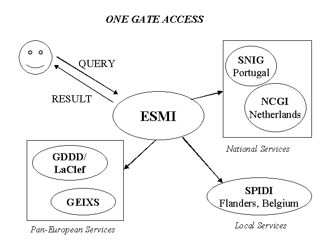
The figure above shows the ESMI intention to link existing metadata services.
It was planned to have a prototype available by the end of 1998 but the project is unfortunately late. It is expected to have a workable prototype during the second half of 1999.
- LaClef is a metadata service developed by a project consortium co-ordinated by MEGRIN
LaClef is an INFO2000 project aimed at unlocking the geographic information held in the public sector. It will improve the existing MEGRIN metadata service called GDDD, particularly by including a multi-lingual interface, the use of profiles and keywords and in linking with geological metadata. LaClef also has the objectives of creating a prototype system to demonstrate the on-line delivery of data by e-commerce and of liaising with the GEIXS metadata service project proposing geological information. The service will be available in the year 2000.
- AVID Project (Added Value Information Dissemination from hydrological data sets)
AVID is a shared cost project supported by the INFO2000 programme. It will develop metadata about bathymetry, coastal topography, sedimentology, waves, current, tides and landmarks. The AVID project aims to demonstrate the effectiveness of a European information service based on hydrographic services held by the public sector.
- CLEAR (Spatial Data Clearing House Saar-Lor-Lux)
http://www2.echo.lu/info2000/en/factsheets/clear.html
At the regional level, initiatives also exist to make geographic information more visible. For example, CLEAR is an INFO2000 metadata project aiming to help solve problems associated with assembling cross-border geographic information from Germany, France, Belgium and Luxembourg. The project is being co-ordinated by Luxembourg's Bureau d'Etudes et Service Technique. The service will be available in French and German.
- MADAME (Methods for Access to Data and Metadata in Europe)
http://www2.echo.lu/info2000/en/factsheets/madame.html
MADAME is part of the INFO2000 programme. Focusing on geo-statistical data and cadastral data, it will evaluate current services providing access to data and metadata at European, national and local levels (evaluate the current strengths and limitations of metadata service provision, identify the data needs of users for instance). It will deliver a Web-based data and metadata site explaining the methodologies for metadata.
- GISEDI Europe
The GISEDI Europe project (Telematic Applications Programme) aims to develop a European commercial and technical network infrastructure which will facilitate and accelerate the exchange and trading of geographic information at the local, regional and international levels. The output of this project is a book of specifications for a GI broker service, which will provide the organisational and technical basis for the development of a GISEDI systems. The specifications will be tested in four pilot sites located in Greece, Spain, Portugal and Finland. The project will be completed in June 2000.
- REPORTS
In France, CERTU (Centre d'Etudes sur les Réseaux, les Transports, l'Urbanisme et les Constructions Publiques) and CNIG (Comité National pour l'Information Géographique) have recently launched REPORTS. This is a tool that will be freely available on the Internet, downloadable from the CNIG website in the near future, to help and support metadata capture. Guidelines and documents to support metadata capture were also produced and will be available from the CERTU website.
2. Analysis - Problems
2.1 Main European achievements
A European standard but...
It is quite obvious for those who have tried to access to a copy of a CEN pre-standard that it is not a trivial exercise. In short, one can say that purchasing 'ENV 12657 Geographic Information - Data description - Metadata' needs from the buyer a good understanding of the CEN rules and process. In addition no implementation guidelines and no training facilities are included in the package.
A limited number of experts in standardisation
As no CEN implementation guidelines exist independent consultants propose different solutions to implement the pre-standards.
A series of non-coordinated and non-interoperable services
Annex 1 and chapter 1.3.2 present a long list of initiatives that were developed in a consortium or individual approach. There is little communication between the initiatives and even less interoperability.
2.2 Difficulty in selecting and implementing a standard
A critical choice: CEN or FGDC or wait for ISO?
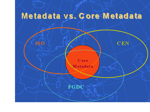
It is well known that in many European metadata projects this crucial issue has been raised. To avoid facing the consequences of a wrong choice, some projects had the vision to identify and use a core common to the three standards. MEGRIN is heavily involved in the definition of this core and has proposed:
"MEGRIN defines the core as the minimum information necessary to provide user with an effective service and access to European data sets. This limited number of metadata elements should enable a service with thesaurus and keywords to facilitate searching and allow the user determine:
- whether a data set exists for the purposes required;
- the specifications and quality of that data set;
- the area covered by the data set;
- full contact information to access the creating organisation."
The following figure presents the core in term of a common part of the three main international standards.
Investing in learning the standard or using a standards expert?
The majority of standards are very difficult to understand and to implement. That is why many metadata "builders" are hesitating to start the process of learning and implementing several standards. Some have found it more convenient to have the support of standard experts, each of which has personal vision on how to implement a standard. It is necessary to insist in saying that to be used correctly, a standard has to be well documented and promoted and that training facilities have to be provided. It seems this effort is not sufficiently made by the standard makers and in particular by CEN.
2.3 Existing services do not communicate
At present metadata services do not communicate with each other with the result that there is duplication and inconsistency.
ESMI has the objective to link existing and future spatial metadata systems. The exploration and implementation of the more appropriate technology are not trivial exercises and need consequent resources.
A working application of the linking of remote information services can be seen at the Global Environmental Information Locator Service (GELOS - http://unfccc.gelos.org/). This is the G7- Environment and Natural Resources Management (ENRM) globally distributed virtual library of ENRM data. The alpha-version of GELOS is hosted by the Centre for Earth Observation of the European Union and uses the GELOS metainformation attribute set to describe its resources. The long-term result of this effort will be a virtual library of ENRM information held in globally distributed sites that are accessible via increased electronic linkage between networks and thus integrate distributed ENRM data and information databases.
2.4 Capturing and maintaining metadata is not always seen as a priority by data producers
Metadata capture and maintenance is still seen as a time consuming and consequently expensive activity. The fact that in the public sector in which a large part of geographic information is produced the creation and maintenance of metadata is not a legal obligation (in the majority of the cases) does not help. For those organisations who have a culture of describing and disseminating their information it is often the case that old methods and technologies are in place since a long time and it seems difficult to change the situation, in particular with regard to the personnel issues. The necessity for data producers to have access to, and to use, capture and maintenance tools at a very low cost is identified as a success factor.
2.5 Minimum collaboration with users during the definition and implementation phases: a user-friendly focus is needed
User-friendly interface
For a non-professional user, finding the information wanted is very difficult. Even if 'Help' or 'Tutorial' can be found in some metadata services such as EWSE, it is not very easy to understand what to do and where to type. Efforts must be made to explain what to ask for and to develop user-friendly and multi-lingual interfaces. If it takes too much time to understand how to react to metadata services, users will not stay long and will immediately complain! A dictionary, multilingual thesauri or catalogues with keywords, should be provided to users to ensure that the same vocabulary is used. One of the most important things is to develop services that are not technology dependent and technology driven. Projects must be done in collaboration with users (who must first be identified).
User-expected content
Are we certain that the metadata content now available from the various existing services is that expected by the users? It seems that the current tendency is to propose a complex database approach that seems to be very 'data producer oriented'. One can imagine that users are more interested in examples and benefits on how to use the proposed data sets than a detailed description of its structure and content. To our knowledge a study on feedback from users of the existing services in Europe does not exist.
2.6 Potential users are facing initiatives which are not well documented and advertised
The aim, end product and inter-relation of each project are not sufficiently clearly documented. It is not obvious for users to understand and identify the most appropriate service for their needs.
2.7 Doing business with metadata seems impossible
With the exception of selling expertise in implementing standards and developing metadata services, there is a general opinion that selling metadata is not a feasible business model.
2.8 Metadata for applications
A new tendency is to adapt the metadata structure and content to applications, for example, electronic commerce or data management within an organisation. Metadata that is created to satisfy a real need, rather than because it is seen as something that should be done in the general interest, is more likely to be well-written and maintained.
2.9 Several metadata descriptions of the same data set
Across the existing services there are likely to be different metadata descriptions of the same data set, e.g., metadata descriptions from the Portuguese national mapping agency in the SNIG service and the GDDD.
2.10 Lack of a GI product identification mechanism
There is no mechanism to provide identification numbers (Id) to the different GI products produced and offered to users. This missing element is a very important issue for those who are implementing in parallel a metadata service and an e-commerce solution.
3. Solutions - Proposals
3.1 Seek consensus as to with which standard Europe should be working
Quarrelling during too long a period about using one standard or another (CEN versus ISO) and a language or another (EXPRESS versus XML) will not help the implementation and development of metadata services. It is time to seek consensus on with which standard Europe should be working. The use of a common contents standard in Europe (common specification on metadata content, semantics, formats and language) is fundamental.
3.2 Manoeuvre to generate a period of stability with the focus on implementation, seek consensus on 'how to implement'
A period of stability in the standardisation process of two to three years is needed to focus on implementation. Furthermore a consensus on how to implement is necessary to generate interoperable solutions at a minimum cost.
During that period, more efforts like the Danish one (http://www.geodata-info.dk/), in which they are experimenting and developing the use of the XML language for seamless transfer of metadata have to be made and experiences need to be shared within the GI community.
3.3 Gather user feedback and identify user needs
Metadata content and services should not be producer-oriented and users should be involved in the metadata process. However, not only professional users should be contacted to give feedback on metadata services but also "basic users". Indeed they could help to identify the vocabulary they use, the type of interface they need, etc. In short usability studies have to be promoted.
3.4 Organise a co-ordination process and clustering approach across projects and initiatives
The creation of a working group responsible for the co-ordination of all metadata projects in Europe could be envisaged. This working group should be related to the planned High Level Working Party proposed in the draft GI2000 communication.
In parallel a clustering approach across projects and initiatives shall be developed. Some clustering activities have already started, such as the preparation of an agreement between GISEDI, ESMI, LaClef and GEIXS by which the projects 'agree to further collaborate in the maintenance of the initial GI core metadata, by continuous contact, aiming at sharing mutually beneficial relevant information'.
3.5 Provide incentives for metadata creation and maintenance
The impressive list of incentives which includes financial resources, knowledge and expertise, standard and tools provided by the FGDC (Federal Geographic Data Committee - http://www.fgdc.gov/) to stimulate the creation and maintenance of metadata content and services within the concept of the US Clearinghouse appeared to be a key success factor of the US metadata initiative.
It is important that national governments and the European Commission provide such incentives to metadata builders. Some have started, such as France that provides free tools and documentation to metadata builders developed by using government funding.
3.6 Envisage legislation for public sector metadata content
In countries where legislation is the main engine for creating new or adapting existing public sector activities and in the situation that the GI public sector does not start describing or does not describe enough their information, then the creation or adaptation of laws and the missions of these organisations should be envisaged.
3.7 Study and implement a GI product numbering mechanism
To make the e-commerce of GI a reality a study on how a GI numbering system could be organised and implemented and by whom should be made. This system could be similar to the ones used for other products, such as books.
The implementation of a GI product numbering mechanism has to be operational in the very short term.
CONCLUSION
Are metadata really so useful?
Do other solutions to this strategic problem exist?
Would it be better to let the market create a metadata infrastructure instead of trying to make it institutionally?
There is a clear consensus within the GI community, at this stage in the data and metadata capture and management process and of technological development - in particular those concerning intelligent search engines on the Internet - that metadata content and services really are necessary to increase the visibility of the existing content and to facilitate access by users to geographic information.
Some argue that if simple catalogues of data sets are placed on the Internet the users can use intelligent search engines to identify the content they need, who the owner is and how to access it. Have you tried it? Searching for example 'route+France' using 'VOILA' will give you some results that you will have to analyse. Some results are quite surprising and are away from your main interest. If you really need information on the existing GI for which you are searching then you will need time and effort to reach an acceptable answer to your problem.
The first conclusion is that the efforts to document the multitude of existing data sets should continue and be reinforced. Metadata services have to be developed in a more standardised and co-ordinated way.
The last point is to consider if a market approach, as is mainly the case for GI content in Europe, is preferable to an institutional one, such as the CEO/EWSE-INFEO initiative for Earth Observation data and now 'non Earth Observation data' (both types can be considered as geographic information) mainly funded by European Commission and the Member States.
It was mentioned above that market studies have demonstrated that there is only a weak business case for metadata services. GI market actors, such as software vendors and of course data providers are proposing metadata services as a complementary service to their main commercial activities (selling software, consultancy, data, etc). Are these services sufficient? Do they meet users' needs? Are they exhaustive? Is the content updated? The 'pros' of a market approach will answer yes and that even if it is not currently the case the improvement will come from the competition. The 'cons' will answer no. A neutral (from software and data vendors interests) GI broker approach is certainly a good solution in a market-based approach.
Others have an institutional vision to maintain neutrality and to keep the dimension of universal service. In this case a political mandate and funding from government, as well as the mandate of the GI community are necessary both at the European level and at the level of Member States.
The real world and in particular in Europe will ensure that the approaches will coexist. The challenge is to create the mechanism to have the two developments inter-linked and coherent. The final user should not suffer from this situation. A GI High Level Working Group with membership from the public and the private sectors should be in charge of this liaising exercise.
The second conclusion is that the two approaches (institutional and market) have to be liaised.
So "retroussons nos manches", more work has to be done at the political, organisational and technological levels to improve the metadata situation in Europe. Many challenges are in front of us and some are specific to Europe, such as the multi-cultural and language issues. It should be firmly stated again that without a strong political commitment of the European institutions and of the Member States, the GI metadata situation in Europe will not improve at the speed it should.
ANNEX 1: SURVEY OF ON-GOING INITIATIVES
The following is a survey made by the ESMI (http://esmi.geodan.nl/) consortium:
National or Local Spatial Metadata Services and Initiatives in Europe
Denmark: http://www.geodata-info.dk/
The Infodatabase on Geodata is a catalogue, describing the digital maps and other collections of geo-related data in Denmark. The metadatabase gives a short overview of each data set, and where to get further information about the data set. Over 40 organisations have provided descriptions of their data sets. KMS - the National Survey and Cadastre - has responsibility for the running the service. A reference group has been set up to steer the work representing important interests on the user and data producer sides.
Finland: http://www.kartta.nls.fi/index.html
With MAPSITE - a WWW map service provided by the National Land Survey of Finland - you could browse maps at different scales on your own computer screen.
France: http://www.cnig.fr/index.fr.html
The Catalogue des Sources coordinated by AFIGEO/CNIG, provides information about publicly available geographic data sets that cover, or will cover, the whole of France.
Germany: http://a5.leipzig.ifag.de:8080/metainfo/plsql/metainfo.meta_start?inf_sprache=eng
On behalf of AdV, the Bundesamt fur Kartographie und Geodasie (BKG) is maintaining the ATKIS Meta Information System for topographic data of the 16 mapping agencies of the Laender. Each state survey office generates its own metadata and transfers it to the geodata centre of the BKG.
Hungary: The METATÉR project - the development of a unified spatial metadata service for the Hungarian public administration - is among the primary tasks of the Prime Minister's Department.
Ireland: http://www.tcd.ie/Geography/GIS/metadata.html
Research is underway to develop an 'Information Clearinghouse' for the Irish Geographical Information market, based on those developed in the EU, United States and Australia. The Irish Geospatial Information Directory (GeoID) will promote co-ordination and awareness within the Irish GI marketplace through the development of a meta database of available geographical information resources.
The Netherlands: http://www.geoplaza.nl/Profiel/profiel.html
The National Clearinghouse for Geographic Information (NCGI), coordinated by Ravi and developed by Geodan provides information about public and private geographic information.
Norway: http://www.statkart.no/ngis/index.html
NGIS Geodatakatalog for Norge is a catalogue of data sets available from the national mapping agency Statens kartverk. Other organisations have their own metadata services.
Portugal: http://snig.cnig.pt/snig/english/index.html
The National System of Geographical Information (SNIG) is co-ordinated by the Centro Nacional de Informação Geográfica (CNIG). SNIG provides access to geographic information produced by national public agencies within environmental, agricultural, economic, scientific and cultural domains. The information included in SNIG is catalogued to allow an easy and fast access to the data. Through these catalogues the user can find where and what cartographic and alphanumeric data is available. Users can also find the latest innovations and organisations associated with geographic information.
Slovenia: http://www.sigov.si:81/giceng/index.html
The Geoinformation Centre of the Ministry of Environment and Physical Planning has a national catalogue of geospatial data sources in which over 400 data sets are described from various sectors and ministries.
Sweden: http://www.lm.se/samgis/databaskatalog/katalog.html
Since 1992 the National Land Survey has had responsibility for the National Metadata Catalogue. This now contains nearly 150 data set descriptions from nearly 40 organisations.
United Kingdom: http://www.ngdf.org.uk/
Under the National Geospatial Data Framework, Discovery Metadata Guidelines have been prepared as the first stage in the development of metadata services for the discovery of data resources that have a geographic component. The aim of the guidelines is to provide a consistent and simple method of documenting any data resources that are referenced in some way to the earth's surface.
Flanders, Belgium: http://193.58.158.196/metadata/
The Spatial Information Directory (SPIDI) developed by the GIS-Flanders Support Centre contains descriptions of some 200 data sets in Belgium.
Europe Wide Services
EEA: http://www.mu.niedersachsen.de/system/cds/
The European Environment Agency is developing its Information Locator Service as a multilingual service to locate environmental information resources. The service is centred on the European Catalogue of Data Sources CDS
ESRI, UK: http://www.data-store.co.uk/
DataStore is an on-line ordering service for geographic data sets. The data sets are provided by a large number of specialised data provision companies and organisations with whom ESRI (UK) has developed links. DataStore provides an easy way of browsing the data available by category. You can gain more information about the specifics of the data, view screenshots and see the pricing structure for data sets. The data sets are mainly of European countries although there is some worldwide data available.
EuroGeoSurveys: http://www.eurogeosurveys.org/
GEIXS - Geological Electronic Information eXchange System or the European Geological Data Catalogue - is a metadata server of harmonised geoscientific information.
MEGRIN: http://www.megrin.org/gddd/gddd.html
GDDD - the Geographical Data Description Directory - contains information on the digital geographic information available from Europe's National Mapping Agencies (NMAs). Contributions from more than 36 NMAs are included in the GDDD, which is based on the CEN/TC 287 European Pre-standard ENV 12657:1998 Geographic information - Data description - Metadata.
World Wide Services
CEO: http://ewse.ceo.org/anonymous/indexpage/overview.pl
EWSE - An Information Exchange for Earth Observation is an on-line information service for the Earth Observation community. It was developed by the Centre for Earth Observation (part of the European Commission's Joint Research Centre) to help new and existing users find data and services and to allow service and data providers to find users. EWSE hopes to expand and promote the application of the wealth of data gathered by satellites.
During 1999 INFEO (http://www.ceo.org/infeo.html) - Information on Earth observation - will replace EWSE, the CEO's current Earth observation information exchange system. In addition to all functionality currently offered by the EWSE, INFEO will for the first time allow on-line searching of major data collections. This functionality is enabled by the use of Catalogue Interoperability Protocol (CIP).
ESRI: ArcData Online (http://www.esri.com/data/online/index.html) is an Internet mapping and data site. The site contains a wide assortment of geographic information that users can access to create map images and download data.
MapInfo: MapInfo Express Mapping Superstore (http://www.mapexpress.com/) provides product and data information.
Oddens's Bookmarks (http://kartoserver.frw.ruu.nl/html/staff/oddens/oddens.htm) - links to web based mapping resources.
UNEP: DEIA/GRID (http://www.grid.unep.ch/mdd/home.htm) - Geneva is a United Nations Environment Programme centre for environmental information and assessment, with major activities and responsibilities in geo-spatial data and information management; capacity building and servicing; and environmental assessment and reporting. They have developed the UNEP Meta-data Directory as a library card catalogue of environmental information. It contains ''card entries'' (or meta-data descriptions) of institutes and data sets.
ANNEX 2: ACRONYMS
AFIGEO: Association Française pour l'Information Géographique
AVID: Added Value Information Dissemination
BKG: Bundesamt für Kartographie und Geodäsie
CEN: Comité Européen de Normalisation
CEO: Centre for Earth Observation
CERTU: Centre d'Etudes sur les Réseaux, les Transports, l'Urbanisme et les Constructions Publiques
CDS: Catalogue of Data Sources
CNIG: Comité National pour l'Information Géographique (France)
CNIG: Centro Nacional de Informação Geográfica (Portugal)
ESMI: European Spatial Metadata Infrastructure
FGDC: Federal Geographic Data Committee
GDDD: Geographical Data Description Directory
GEIXS: Geological Electronic eXchange System
GI: Geographic Information
ISO: International Standards Organisation
MADAME: Methods for Access to Data and Metadata in Europe
NCGI: National Clearinghouse for Geographic Information
NGIS: National Geographic Information System
NMA: National Mapping Agencies
OGC: OpenGIS Consortium
SNIG: National System for Geographic Information
SPIDI: Spatial Information Directory